Idan – Seeing the World in 3D Oblique
Idan – Seeing the World in 3D Oblique
Introduction
Over the years, Idan Computers Ltd. and Phase One developed a productive relationship in order to support their customers with a unique combination of Phase One metric cameras for oblique use and Idan’s matching software for generating highly accurate data of buildings, landscapes and other 3D objects. The main goal of this cooperation is to provide a turnkey solution for any kind of 3D survey based on aerial imagery and to provide data to a wider group of professionals.
Idan was established in 1970 by a group of engineers and scientists to develop computer-based methods for civil engineering in the road and construction sectors. They offered road design services as well. At that time, their software used DTMs, which they collected using terrestrial methods to generate contour line models. The software was mainly used for road and construction design. In many projects, Idan created the design, and the data was used as a base for the construction.
In the 1990s, Idan used aerial images to generate data and was one of the first companies to augment the nadir view images with oblique images, making the company a true pioneer in the industry.
As the aerial data acquisition market matured, Idan recognized that aerial images could be used for many more applications, beyond simple orthophoto production, which was the main use for aerial images at the time. Idan found that nadir imagery was useful for measuring flat objects parallel to the ground, but did not address the need for viewing and measuring vertical objects and their distance from the ground.
Oblivision
Having experience with oblique imagery, Idan developed a software system called Oblivision in order to assist engineers in viewing and measuring 3D objects. Their existing customers from the civil engineering field started working with Oblivision. The concept caught on and new users quickly adopted the software for additional purposes, such as, homeland security, police, military and environmental studies. For these new customers, Oblivision offered a new way of exploring their specific fields.
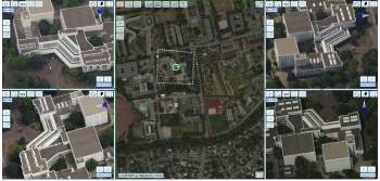
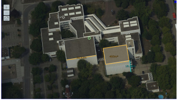
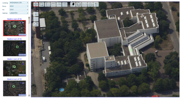
When using Oblivision, the software requires a DTM, orthophoto, calibration data of the camera (interior orientation) and IMU/GNSS data (exterior orientation). Based on this information, Oblivision generates fully georeferenced data for each oblique image. This output enables users to see any point of the orthophoto from four sides, based on the oblique images, and to use the data for many purposes including measuring points, distances, areas, volumes and to analyze the 3D information.
Best Performance
Idan found that Oblivision performed best when using high resolution images and camera calibration data. This is a key for obtaining reliable and high quality results. Based on the images obtained from Phase One’s iXU and iXA cameras, Idan incorporated the specs of the cameras in their software to enable users to select Phase One metric cameras for Oblivision projects. As soon as the Phase One iXU 1000 was released, it was quickly incorporated into Oblivision as a number of Idan’s customers upgraded their Phase One cameras or purchased the new platform. Idan has sold software licenses to Phase One users around the world.
One of these customers, which recently upgraded their iXA 180 to the iXU-R 1000 (100 MP), has performed over 40 projects in the last two years using the combination of their Phase One camera and Idan’s Oblivision software. “We are excited to support the new Phase One 100 MP camera, with its unprecedented resolution. The camera reveals even the smallest detail that could not have been seen previously.” Said Joseph Freund, CEO and founder of Idan. He further mentioned: “The results we obtained from a joint project with GGS Gmbh of Germany, designing, building and using a five-head oblique camera system based on Phase One iXU and iXA cameras, move oblique data acquisition to a new level of detail and accuracy.”
Oblivision and UAVs
With the growth of the UAV market, Idan adapted their software to enable UAV users to capitalize on the success obtained with manned aircraft flights. They defined a way to fly UAVs in a special pattern over a site. This allowed data generation for a project in the minimum amount of time. For a half square kilometer site, a two hour flight and two hours of post processing enable data delivery in less than a day, which can have a great impact on cost savings and profit generation for the service provider.
When the aircraft use Phase One iXU cameras, the accuracy and details can make the aerial data more valuable with the higher level of information. By using a Phase One iXU with a 100 MP sensor, users can shorten flight times and with the resulting larger footprint, reduce the number of images to a minimum. This has an impact on flying and post processing time, which increases the profitability of the system and enables a faster return on investment.
Oblivision Viewer
To view, measure and analyze the data, Oblivision offers two different kinds of viewers. One is a desktop-based version, which enables users to perform the analysis on their personal workstations. This version is mostly used by homeland security or police forces, which may require quick and confidential access to the data in situations where a local network may not work properly in the case of a network issue or a power outage.
The second version of the viewer is cloud-based, and enables users to work with the software and the image data via the Internet or an Intranet, accessing the data, which is located on a server. This viewer version is designed in a way that users, within the same office or all around the world, can work on one data set at the same time. This is especially useful for GIS applications or in the civil engineering sector, where the different layers within a single data set might be needed by different departments for a number of purposes. The web-based version of Oblivision can provide images produced with Phase One cameras to hundreds of users working on the same job, analyzing their specific demands. Sharing a one-time acquired data set with different end users can result in vast cost savings.
The viewer can be integrated with the most common GIS software packages. For ESRI software, the viewer can be directly integrated into the ESRI GIS suite so that users can enter information directly into a GIS database.
Takeaways
The combination of Idan software and Phase One cameras opens new possibilities in oblique image acquisition and surveys. Phase One cameras can be used as a standalone unit mounted on a UAV for oblique image capture or as part of a multi-head solution with five or more cameras together in an array. In both cases, the image quality and the level of detail that can be captured opens doors to new projects and shortened flight times by using 100 MP sensors. When Oblivision software employs images from Phase One aerial cameras, a new accuracy standard with real metric values can increase revenues by delivering complete new data sets to customers in a minimal amount of time.
More information that might interest you
ObliMapper Transforming Drone Imagery into Actionable Visual Intelligence
IDAN Computers’ ObliMapper uses UAVs to capture aerial images and…
Read MoreMetric oblique image collection with UAVs (November 2016)
IDAN Computers’ ObliMapper enables metric oblique image collection using UAVs…
Read MoreTatukGIS DK Used for Homeland Security and Military Mission Planning Software
IDAN Computers uses TatukGIS DK in its IMPS™ and Oblivision™…
Read More